
CoProcess 2025: Revolutionizing Point Cloud Vectorization for Survey Professionals
- Michelle Hands
- Aug 20, 2025
- 4 min read

The surveying and mapping industry has witnessed remarkable growth in handheld SLAM (Simultaneous Localization and Mapping) technology, with over 1 million users worldwide. However, a critical gap has emerged between advanced data capture capabilities and efficient post-processing workflows. CHC Navigation's recent webinar introducing CoProcess 2025 addressed this challenge head-on, presenting a comprehensive solution that promises to transform how professionals handle point cloud vectorization.
The Industry Challenge: From Data Capture to Deliverables
Despite the rapid adoption of SLAM technology across neighborhood renovation, topographic mapping, property surveying, and heritage conservation projects, professionals have consistently faced significant bottlenecks in the office. The webinar highlighted several persistent pain points:
Software lag and crashes when handling massive datasets
Fragmented workflows requiring multiple software platforms
Inconsistent deliverables due to limited CAD compatibility
Time-consuming vectorization processes that reduce overall project efficiency
Research presented during the webinar revealed that over 60% of SLAM users actively seek better vectorization solutions, indicating a substantial market need for integrated workflow tools.
CoProcess 2025: The All-in-One Solution
Massive Data Handling Without Compromise
One of CoProcess 2025's standout features is its ability to handle over 100GB of point cloud data in a single session without batching requirements. Built on the second-generation MetaCAD point cloud engine (Meta 2), the software demonstrates a 60% improvement in drawing efficiency compared to traditional AutoCAD workflows.
The software supports up to 5 hours of field SLAM data without lag or crashes, providing a smooth and stable vectorization experience that eliminates the need for data segmentation.
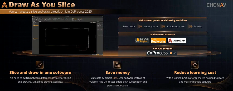
Revolutionary "Draw as You Slice" Workflow
CoProcess 2025 breaks the traditional workflow paradigm by enabling real-time drawing directly on point cloud slices. This eliminates the conventional process of:
Creating slices in point cloud software
Exporting to image format
Importing into CAD software for vectorization
Instead, users can now vectorize directly within a single platform, streamlining the entire process and reducing software licensing costs by approximately 80%.
Comprehensive CAD Compatibility
The software offers full DWG native compatibility across all versions, supporting:
Template import from existing CAD systems
Standard layer management with complete organizational control
Rich symbol libraries featuring over 200 standard symbols, blocks, line types, and hatch patterns
Intelligent dimensioning with automatic area labeling and elevation annotation
Advanced Visualization and Drawing Capabilities
Enhanced Point Cloud Rendering
CoProcess 2025 introduces innovative rendering methods that significantly improve visualization:
Depth rendering mode: A one-click toggle that clarifies boundaries on dark walls and complex surfaces
Transparency rendering: Enables visualization through structural obstructions for indoor mapping
RGB and intensity views: Multiple visualization options for different project requirements
Intelligent Drawing Functions
The software incorporates AI-powered features that enhance accuracy and efficiency:
Box selection mode: Automatically extracts building boundaries from horizontal slices
Edge extraction: Intelligent algorithms automatically fit optimal edges, reducing human error by over 20%
Multi-modal drawing: Seamless switching between vertex, orthogonal, edge, and arc modes within single polylines

3D Model Integration
Uniquely, CoProcess 2025 supports vectorization based on both point clouds and 3D mesh models, particularly when paired with CHC Navigation's RS10 scanner. This dual-data approach provides:
Complete facade information through point cloud and photogrammetric model overlay
Clearer structural definition for complex architectural features
Enhanced boundary recognition in challenging environments
Real-World Applications and Benefits
At PQS tech we have tested both the hardware and software extensively below are some of the examples of projects we have worked on.
Construction site inspections: 10-minute site walks producing comprehensive, accurate documentation
Topographical surveys: Seamless integration with traditional survey control points
Coastal monitoring: Handling hundreds of gigabytes of beach monitoring data efficiently
Heritage conservation: Detailed facade documentation with precise measurements
Hardware Compatibility
While optimized for CHC Navigation's RS series scanners, CoProcess 2025 accepts data from various sources:
SLAM devices from any manufacturer
Terrestrial laser scanners
Vehicle-mounted LiDAR systems
UAV-based mapping systems
Technical Requirements and Accessibility
System Specifications
Minimum Requirements:
Intel i7 processor
16GB RAM
Dedicated graphics card (GTX 3060 or equivalent)
Recommended Configuration:
Intel i9 processor
32GB RAM
RTX 3060 or higher graphics card
Cost-Effective Licensing
Unlike subscription-based alternatives, CoProcess 2025 offers permanent licensing options, significantly reducing long-term operational costs for surveying firms of all sizes.
Looking Forward: Future Developments
The webinar outlined several upcoming enhancements:
Advanced AI extraction for windows, traffic signs, trees, and lighting fixtures
Automated tree measurement including radius and height calculations
Enhanced point cloud classification capabilities
Expanded symbol libraries for specialized applications
Conclusion: A New Standard for Point Cloud Vectorization
CoProcess 2025 represents a significant leap forward in point cloud processing technology, addressing long-standing industry challenges through innovative engineering and user-centered design. By combining powerful data handling capabilities with comprehensive CAD functionality, the software enables professionals to complete entire workflows—from raw point clouds to finished deliverables—within a single, stable platform.
For surveying professionals seeking to maximize the value of their SLAM investments while improving project efficiency and deliverable quality, CoProcess 2025 offers a compelling solution that bridges the gap between advanced data capture and practical project delivery.
The software's launch marks a pivotal moment in the evolution of surveying technology, promising to accelerate the adoption of handheld SLAM systems across diverse applications while reducing the complexity and cost barriers that have historically limited their widespread implementation.


Comments